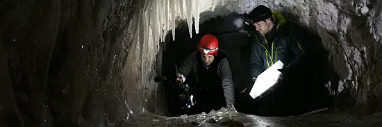
Among the few current permafrost deposits in Germany is the Zugspitze, 2962 m above sea level. Germany's highest mountain. Right next to the Summit's 3700 years ago, a 300-400 million. solved m³ large landslide and spread as a fall in the current pool of Garmisch-Partenkrichen to 16 km ². Several authors assume that the warming of the permafrost has prepared the landslide during the Holocene climatic optimum (Gude and Bass, 2005; Jerz and Poschingerstraße, 1995). Permafrost was also the construction of the funicular 1928-1930, the construction of the cable car from the Eibsee 1960-1962 and the extension of the cog railway in 1985 again on the top and on the Zugspitzplatt encountered (reviewed in Krautblatter et al, 2010;. Ulrich and King, 1993). The history and evolution of permafrost on the Zugspitze is important for a scrupulous assessment of the current and future development of the study area in relation to the adaptation processes due to climate changes (Verleysdonk et al., 2011).
Today, the permafrost on the Zugspitze is under intensive monitoring. The Bavarian State Office for the Environment has directly under the cable car station at the Zugspitze peak, a 43.5 m long borehole can drill across the summit in August 2007, which is constantly monitored by more than 20 temperature sensors permafrost. In addition, an attempt was made to simulate the spatial occurrence of permafrost at the Zugspitze with the help of thermal underground models (Noetzli et al., 2010). The review of the statements of such modeling in steep rocky terrain of the Zugspitze, however, is difficult because the local topography of the rocky slopes, the highly variable snow cover and water flows along the separation area and the Karst vessels in the rock have a strong influence on the distribution of permafrost.
Geophysical investigations
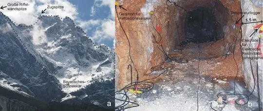
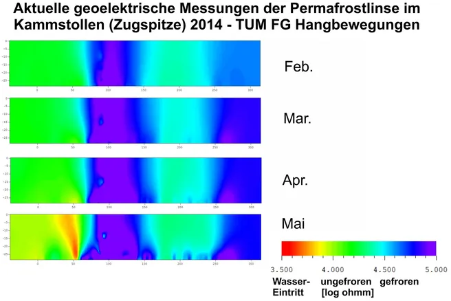
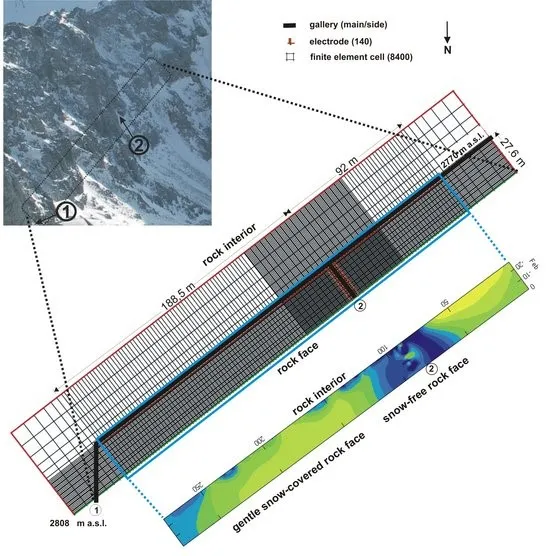
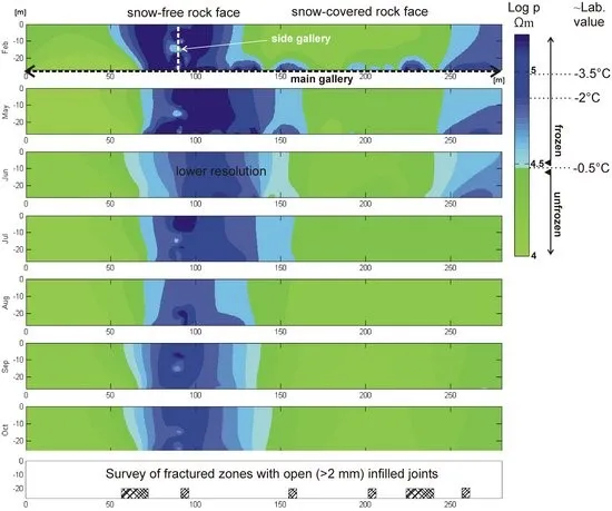
Therefore, the geophysical method of electrical Resistivitätstomographie (Fig. 2) was developed to detect spatial distribution pattern and changes of permafrost can (Krautblatter and Hauck, 2007). At 140 steel electrodes along a 300 m long corridor, which was created more than 80 years ago near the Zugspitze north face (Fig. 1b), more than a thousand combinations measured resistance (Krautblatter et al., 2010). From the resistance values of a two-dimensional tomography of frozen rock is created with the help of so-called inversion method that removed from the canal up to the outer wall 30 m ranges (Fig. 2). The resistivity values of such imaging can be compared with laboratory values of frozen Zugspitze dolomite. Here, a relict permafrost lens with core temperatures shows up on altitude of 2800 m NN (temperature logger see Figure 1b) of -0.5 to -1.5 ° C, which coincides with the steep rocky area on the north wall, which remains snow-free in winter and thus give off much heat can. In the snow-capped in winter north face areas of permafrost has largely disappeared - even the formerly hundreds of meters throughout the year icy Ganges recognizable in tomography 50 m stayed back only.
Changes in permafrost lens
Monthly recurrence of tomographic measurements show the changes in the permafrost lens, which is sensitive to warm summers. After the warm winter 2006/2007, with a more than 2 degrees too warm November to February period compared to 1991-2007, only a small remnant inventory could keep the following summer permafrost (Fig. 2). While the annual mean temperatures on the Zugspitze 1991-2007 (-3.9 ° C) only by about 1 ° C over 1901-1930 (-5.0 ° C), 1931 to 1960 (-4.7 ° C) and 1961 to 1990 (-4.8 ° C) have increased, the measurements show in the comb tunnel the highly sensitive response of permafrost, which can survive on the Zugspitze today just in the steepest north-exposed areas.
Literature
Gude, M. and Barsch, D., 2005. Assessment of the geomorphic hazards in connection with permafrost occurrence in the Zugspitze area (Bavarian Alps, Germany). Geomorphology, 66(1-4): 85-93.
Jerz, H. and Poschinger, A.v., 1995. Neuere Ergebnisse zum Bergsturz Eibsee-Grainau. Geologica Bavarica, 99: 383-398.
Krautblatter, M. and Hauck, C., 2007. Electrical resistivity tomography monitoring of permafrost in solid rock walls. Journal of Geophysical Research - Earth Surface, 112(F2): F02S20.
Krautblatter, M., Verleysdonk, S., Flores-Orozco, A. and Kemna, A., 2010. Temperature-calibrated imaging of seasonal changes in permafrost rock walls by quantitative electrical resistivity tomography (Zugspitze, German/Austrian Alps). Journal of Geophysical Research-Earth Surface, 115: F02003.
Noetzli, J., Gruber, S. and vonPoschinger, A., 2010. Modellierung und Messung von Permafrosttemperaturen im Gipfelgrat der Zugspitze, Deutschland. Geographica Helvetica, 65(2): 113-123.
Ulrich, R. and King, L., 1993. Influence of mountain permafrost on construction in the Zugspitze mountains, Bavarian Alps, Germany, 6th Int. Conf. on Permafrost, Bejing: 625-630.
Verleysdonk, S., Krautblatter, M. and Dikau, R., 2011. Sensitivity and path dependence of mountain permafrost systems. Geografiska Annaler: Series A, Physical Geography, 93: 113–135.
