Munich Alpine Hazards and Mitigation Cluster (AlpHaz)
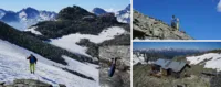
We performed ERT measurements, Laserscans, mapping and more at the Europahütte in order to understand the rock slope at the Austrian-Italian border.
[read more]
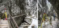
The Höllentalklamm (Höllental Gorge) at the entrance of the Höllental is one of the most scenic parts of the route to the Zugspitze. The TUM Landslide Group collaborates with the DAV Garmisch-Partenkirchen to develop a benchmark safety concept including a wireless sensor network and biannual…
[read more]
Prof. Dr. Michael Krautblatter appeared in German TV two times last week with documentations from Kitzsteinhorn, Zugspitze and Hochvogel (in German).
ARDalpha: Is the Zugspitze falling apart?
BR: Extreme - The new normal? Climate Change in Bavaria
[read more]
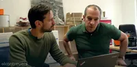
Doctoral researcher Riccardo Scandroglio and Prof. Dr. Michael Krautblatter present their research efforts within an 6.30 min report on climate change. A team of Bayerische Rundfunk (BR) journalists accompanied Riccardo and some colleagues to the Zugspitze, Germany´s highest mountain, where they…
[read more]
The Bavarian TV broadcasted an 8 min documentary in "Gut zu wissen" about the AlpSenseBench project at the Hochvogel on 20.10.2018, 19:00.
Link: Gut zu wissen: Felssturz am Hochvogel erwartet (8 min) (German)
[read more]
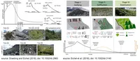
Daniel Draebing recently published two studies on the development of Alpine lateral moraine slopes in the special issue “Paraglacial processes in recently deglaciated environments” in the journal “Land Degradation and Development” (IF 7.27). Fieldwork for both studies were conducted within the…
[read more]
The 3rd fieldwork season within the project “Alpine Rock Slopes” lead by Daniel Draebing took place one and a half weeks in the Gaisberg Valley, Austrian Alps, and three weeks the Turtmann Valley, Swiss Alps. In the Gaisberg Valley, the fieldwork team consisting of the PI and 2 MSc student (upper…
[read more]
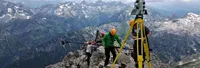
From 09.07. to 11.07.2018 more work has been done at the Hochvogel peak. Members of the TUM Department of Geodesy and Photogrammetry took a detailed record of the summit area. Members of the Landslide Research Group carried out measurements in the crack and installed the first permanent sensors.…
[read more]
On Friday the 15.06.2018 a fair weather window was used to geodetically measure the summit area and the summit ridge on the Hochvogel. In addition, the first measurements with a Gravimeter were carried out and more convergence lines were measured. In total six researchers from the…
[read more]
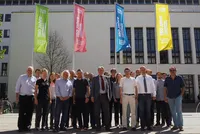
In April the international project group of the AlpSenseBench project met at the Technical University Munich (TUM) to improve and coordinate the working tasks and plans for this summer period. The meeting was led by Prof. Dr. M. Krautblatter and members of the TUM Landslide group, TUM Photogrammetry…
[read more]