Field Measurements
The Chair for Hydrology and River Basin Management holds different field labs in the catchment areas as well as a soil lab and a water lab.
There the scientists of the chair can make essential investigations for their research projects.
The district of Neustadt a.d. Aisch-Bad Windsheim faces significant landscape water balance challenges due to climate change, historic drainage structures, low precipitation, and low groundwater recharge. To address these, the project “GrüneGräben+” has been initiated to improve water retention and promote infiltration. The project aims to enhance water retention in "green ditches" using controllable weirs and develop additional measures with various stakeholders to optimize the landscape water balance. It will also investigate the spatial and temporal infiltration capacity along the ditches and assess the transferability of the measures to the entire Bavaria region.
The project examines three study areas: Buchholzgraben (0.17 km²), Langenwasengraben (1.88 km²), and Bodenfeldgraben (0.34 km²). Buchholzgraben is situated in a geological unit of loess/loess loam and has a storage length of approximately 100 m, with a storage volume of about 56 m3 and a storage height of around 0.75 m. Langenwasengraben is located in the geological unit of gypsum keuper and has a storage length of about 36 m, a storage volume of approximately 10 m2, and a storage height of around 0.6 m. Bodenfeldgraben, also in the geological unit of gypsum keuper, has a storage length of approximately 65 m, a storage volume of about 19 m3, and a storage height of around 0.55 m.
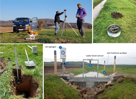
Each weir is equipped with various measuring instruments, including rain gauges, water level sensors, temperature sensors and soil moisture probes. Additionally, in-situ measurements and laboratory analyses are conducted to capture the local soil properties, providing a detailed understanding of infiltration processes. Soil samples are taken at various depths, soil moisture is measured using the TDR method, and infiltration tests are conducted with double-ring infiltrometers. High-resolution digital terrain models of the nearby ditches are created using data from drone flights.